Regional tectonics: from the Rhine graben to the Po plain, a summary of the tectonic evolution of the Alps and their forelands.
Stefan M. Schmid, Geologisch-Paläontologisches Institut, Bernoullistr. 32, 4056 Basel
(html version by R. Bousquet & P. Dèzes)
1. Introduction
Firstly, this contribution gives a short overview of the overall architecture of the Western and Central Alps and their forelands (Po-plain and northern foreland) on the basis of three recent geophysical-geological transects, the locations of which are given in Figure 1. Secondly, the evolution of the Alpine system is discussed in time slices, starting with Cretaceous orogeny and ending with some evidence for very recent movements in the area of the Rhine graben. Some aspects of neotectonics and earthquake hazard are addressed as well, but only as far as they are directly related to tectonic movements which occurred during the geological past.
2. The major tectonic units of the Alps
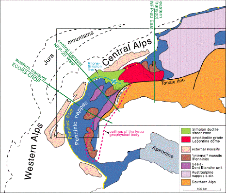
Figure 1 presents an extremely simplified sketch map of the Alps which primarily highlights the transition from Central to Western Alps that will be discussed in profile view along three major transects.
|
Fig. 1: Sketch map of the Alps, indicating locations of the three geophysical-geological transects depicted in Figure 3. From Schmid and Kissling (2000). Large image
|
The Insubric line marks the northern and western boundary of the Southern Alps. The Southern Alps are characterized by a dominantly south-verging fold- and thrust belt whose southern tip is stratigraphically sealed by the Messinian (7 Ma) unconformity below the Po plain. At the base of this very young (Miocene) foreland prism we find the Adriatic middle and lower crust, including the Adriatic mantle, from which 10 to 15 km thick slices, consisting of basement and its Mesozoic sedimentary cover have been detached. This style of deformation points to the availability of a potential decollement horizon within the granitic upper crust within a depth interval of 10-15 km, corresponding to temperatures in the range of 250° to 375°C (assuming 25°C/km). Very probably, this depth corresponds to the brittle-plastic transition within granitic crust. This transition is due to the onset of crystal plasticity in quartz (at about 270°C according to Van Daalen et al., 1999, and/or reaction-enhanced ductility due to break-down reactions of feldspar at about 250°C according to Fitz Gerald and Stünitz, 1993). Before this post-collisional Miocene shortening, hence during Paleogene plate convergence and collision, the lithosphere of the present-day Southern Alps (the Adriatic plate) formed the upper plate, under which the Penninic Valais and Piemont-Liguria oceans, an intervening microcontinent (Briançonnais) and finally the European continental margin were subducted. Figure 1 also depicts the outlines of the Ivrea geophysical body, which represents the western edge of the Adriatic plate. The Ivrea Zone, a belt of South Alpine lower crustal rocks, is the surface expression of the Ivrea geophysical body. Because this lower crust has been exhumed to moderate depth, corresponding to less than 300°C already during Mesozoic rifting, it represents a particularly rigid part of the South Alpine basement at the WNW front of the Adriatic indenter.
Most of the about 100km Oligo-Miocene dextral strike slip along the E-W-striking eastern branch of the Insubric line (the Tonale line) has been taken up by dextral strike slip movements along the Simplon ductile shear zone and the Rhone-Simplon line (Schmid and Kissling, 2000). Hence, from Oligocene to probably recent times, the Western Alps are kinematically part of the WNW-moving Adriatic indenter, causing WNW-directed thrusting along the Penninic front of the Western Alps and within the Dauphinois foreland. The Rhone-Simplon line continues to act as a major discontinuity both in terms of seismic activity and the character of the stress regime up to the present day. During the latest stages of orogeny, this WNW directed indenting by the Adriatic plate possibly migrated further into the foreland, now also affecting the western Molasse basin and causing arcuate folding in the Jura mountains (Burkhard, 1990a).
The Central Alps are characterized by ongoing N-S-shortening during the Oligo-Miocene, i.e. coeval with WNW-ESE shortening in the Western Alps. These diverging transport directions necessitate an orogen-parallel extension, the effect of which is best documented by the Simplon normal fault and the exhumed amphibolite grade Lepontine dome in its footwall. Oligo-Miocene exhumation of the Lepontine dome is the combined effect of orogen-parallel extension, backthrusting along the Insubric line and fast erosion.
The units north of the Insubric line consist of the Austroalpine nappes s.str., outcropping in eastern Switzerland only and extending into Austria. These units, although of similar paleogeographic provenance as the Southern Alps, consist of completely rootless flakes of basement and cover which have been detached (or delaminated) from their lithosphere already during Cretaceous orogeny. These nappes have been stacked towards the WNW and their former (Cretaceous) tectonic front runs almost perpendicular across the present-day Alps in Eastern Switzerland (Grisons). The Sesia-Dent Blanche unit of the Western Alps underwent an alpine tectono-metamorphic history which is different from that of the Austroalpine nappes s.str. and the Southern Alps (subducted near the Cretaceous-Tertiary boundary). However, its pre-alpine basement exhibits close similarities to that of the Southern Alps.
The Penninic units are of extremely heterogeneous paleogeographic provenance (remnants of oceanic lithosphere, a continental fragment referred to as Briançonnais, as well as basement of the European margin). Deformation is penetrative and polyphase, most of the Penninic units are overprinted by metamorphism (except for the Préalpes Romandes which have been detached and transported towards the northern foreland during the Eocene).
The Helvetic nappes have been detached from their former crystalline basement which must be looked for in the lowermost Penninic nappes. The units still attached to the European lithosphere consist of the external massifs and their cover, slightly detached from the lower crust during the Miocene, when deformation started to migrate into the foreland, eventually displacing the western Molasse basin and the Jura mountains by up to 30km from the Serravallian (12 Ma) onwards. The southern Rhine graben represents an Eo- Oligocene continental rift, kinematically linked to the Bresse graben situated west of the Jura mountains and ultimately to the opening of the Western Mediterranean basin (but not to the Alps). The geometry of Oligocene extensional faulting exerts a profound influence on Miocene to recent movements in the Jura mountains and their northern margin in the southern Rhine graben.
3. The major paleogeographic units of the Alps
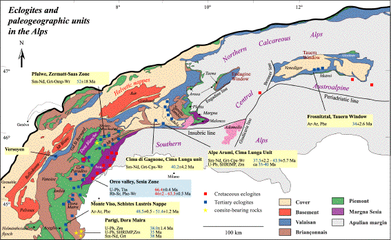
Figure 2 depicts the following major paleogeographic units of the Alps, many of them being only preserved as extremely thin slivers, detached from the subducting lithosphere and accreted as slices (so-called nappes) to the upper plate (Austroalpine and South Alpine units).
|
Fig. 2: Paleogeographic map of the Alps, indicating the present-day position of the major paleogeographic units of the Alps. Note that this is not a "tectonic" map in the traditional sense. After Froitzheim et al. (1996). Large image
|
European margin: External massifs and their cover (extending northward underneath the Molasse basin) and Helvetic cover nappes, whose crystalline substratum has to be looked for within the deepest part of the Lepontine dome (lowermost "Penninic" nappes). Note that the European-derived basement can be traced southward almost to the Insubric line. This drastically illustrates very substantial exhumation of formerly subducted and newly accreted European lithosphere during the formation of the Lepontine dome. Its later exhumation is due to a combined effect of retro-flow (backfolding and backthrusting along the Insubric line) and unroofing by orogen-parallel extension and erosion during the post-collisional stages of orogeny. Note that some of these units also underwent Tertiary eclogitization.
Valais ocean: The remnants of this ocean predominantly consist of Cretaceous Bündnerschiefer, grading into Tertiary flysch and at least partly deposited onto oceanic lithosphere. Eclogitic mafics are preserved in the Versoyen of the Western Alps while blueschists and carpholite bearing rocks (low temperature — high pressure mineral) are preserved in the Engadine window. The Valais ocean opened near the Jurassic-Cretaceous boundary: The remnants of this ocean presently define a northern Alpine suture zone which closed during the Late Eocene.
Briançonnais microcontinent: This microcontinent was attached to Iberia and formed the northern passive continental margin of the Jurassic Piemont-Liguria ocean, before it broke off the European margin in conjunction with the opening of the Valais ocean. The Mesozoic cover of the Briançonnais microcontinent largely consists of platform sediments with frequent stratigraphic gaps ("mid-Penninic swell").
Its basement is preserved in the form of the Tambo-Suretta, Maggia and the Bernhard-M.Rosa nappes in the eastern, central and western Penninic realm respectively. Detached cover nappes form a substantial part of the Préalpes Romandes.
Piemont-Liguria basin: Oceanic lithosphere formed during the middle Jurassic to Early Cretaceous and is characterized by a classic alpine ophiolite suite. Sea floor spreading was followed by the deposition of radiolarites and aptycha limestones. During the Cretaceous the deposition of trench deposits (Avers Bündnerschiefer of Eastern Switzerland and schistes lustrées of Western Switzerland) indicates that the southern, i.e. the Apulian, margin of this basin had been converted into an active margin. In eastern Switzerland the Piemont-Liguria units (Arosa and Platta unit) were involved in top-WNW Cretaceous orogeny. However, the Piemont-Liguria ocean did not completely close before the onset of Tertiary orogeny.
Margna-Sesia fragment: A small fragment of the Apulian margin, that was rifted off Apulia during the opening of the Piemont-Liguria ocean, was later incorporated into the accretionary wedge along the active northern margin of Apulia.
Apulian margin: North of the Insubric line this southern margin is only preserved in the form of rootless basement and cover slices (Austroalpine nappes s.str.). South of the Insubric line it corresponds to the Southern Alps and their lithospheric substratum, the Adriatic plate (part of the larger "Apulian" plate). A third oceanic domain, the Meliata-Hallstatt ocean, formed during the Triassic. It is only preserved in eastern Austria and merely plays a role for understanding Cretatceous (Eoalpine) orogeny.
4. Three major Alpine transects and their deep structure
The major features common to all three transects, schematically sketched in Figure 3, are
(1) ESE to south directed subduction of the European lithosphere,
(2) a gap between European and Adriatic Moho,
and (3) the presence of wedge-shaped bodies of lower crust, largely decoupled from the piling up and refolding of thin flakes of upper crustal material (the Alpine nappes).
However, there are very substantial differences in the geometry and kinematic evolution of the eastern transect (Figure 3c) as compared to the western and central transects (Figure 3a and Figure 3b, respectively).
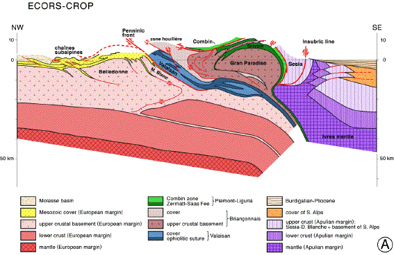
Fig. 3a (large image)
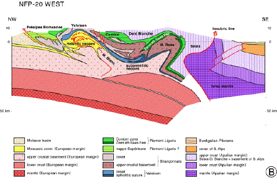
Fig. 3b (large image)
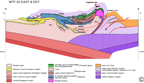
Fig. 3c (large image)
|
Fig. 3: Three schematic geophysical-geological cross sections through the western and central Alps (profile traces indicated in Figure1). Superimposed circles mark weel-locatable earthquake foci for the 1980-1995 time period, projected into the sections from within a 30 km couloir.
|
The following observations can be made:
1. In the eastern (NRP-20 East) transect (Figure 3c) the Adriatic Moho descends northward and toward its contact with the lower (European) crust), while in the central and western transects (Figure 3a and Figure 3b) this same Adriatic Moho rises toward the surface when approaching the contact zone with the European lithosphere. This contrast finds its expression also in the surface geology. In the eastern transect the southern Alps form an impressive south vergent foreland fold and thrust belt ("retro-wedge") riding above the Adriatic lower crust, while this same Adriatic lower crust is exposed in the Ivrea zone, situated at the SE end of the central and western transects. The Ivrea zone and Ivrea geophysical body wedge out eastward and do not extend into the area covered by the eastern transect.
2. In the eastern (NRP-20 East) transect a wedge of Adriatic lower crust is found above European lower crust and below European upper crust at its northern tip. This slice of Adriatic lower crust was wedged into the European lithosphere during the Miocene, splitting apart along the boundary between the upper and lower crust. For the western (ECORS-CROP) and central (NRP-20 West) transects a somewhat similar but geometrically different process of wedging is inferred. In these latter two cases, however, the lower crustal wedge is interpreted to be derived from the European lithosphere. Hence the wedges of lower crust seen in the eastern (Figure 3c) and the western and central transects (Figure 3a and Figure 3b), respectively, are of different origin and, thus, cannot be laterally connected. The observation discussed above, which implies that the Adriatic lower crust descends below the Penninic nappe stack in the eastern profile while it rises to the surface in the western transect, independently supports the conclusion that the two lower crustal wedges are not laterally connected.
3. In the area immediately north of the Insubric line, the eastern transect (NRP-20 East) exhibits substantial back thrusting and backfolding of all the Penninic nappes, including the Valais suture zone. This was associated with exhumation of the amphibolite-grade Lepontine dome and the deep-seated Bergell. In the western transect (ECORS-CROP), however, back thrusting does not affect the Valais suture zone and appears to be restricted to the units above this suture (within the Briançonnais upper crust). Note that Barrovian-type amphibolite-grade rocks have not been exhumed to the surface in the western transect, where the Insubric line only exhibits minor vertical offset.
4. The orogenic lid of the Austroalpine nappes, under which Penninic and Helvetic nappes were accreted in the eastern transect, is absent in the western and central transects.
Well-located earthquake foci have been orthogonally projected over a maximum distance of 30km onto the transects of Figure 3. Comparing (Figure 3a, Figure 3b and Figure 3c) significant differences are evident in the depth of seismogenic regions. The maximum depth of earthquakes is situated near the Moho in the northern and southern forelands along the eastern traverse (Figure 3c). Beneath the Penninic units, i.e., within the Lepontine metamorphic dome, they are restricted to the thickened upper crust. Also note that the Adriatic lower crustal wedge is quiescent. Coincidence of the lower limit of seismicity with predicted isotherms based on thermal modelling (Okaya et al., 1996) suggests that the 500°C isotherm controls the cataclastic-plastic transition. Quiescence within the Adriatic lower crustal wedge further suggests that stress transmission between the European and Adriatic lithosphere is largely restricted to upper crustal levels in case of the central Alps.
In contrast, the earthquake distribution along the western and, to a lesser degree, along the central transects exhibits a wide, east dipping corridor of foci affecting the entire transect, including the allochthonous European lower crust (Figure 3a and Figure 3b). Thus, mechanical coupling and stress transmission between the Adriatic microplate and the European lithosphere occur along a deep-reaching seismogenic zone. This indicates a contrasting (with respect to the eastern transect) present-day thermal regime, primarily caused by the following substantial differences in the kinematic evolution. Firstly, oblique convergence and collision in the western Alps before 35 Myr ago must have led to a significantly smaller volume of accreted radiogenic upper crustal rocks, as compared to the central Alps, the latter being characterized by head-on convergence and collision. Secondly, double verging displacements of the central and western Alps after 35 Myr ago allowed for orogen-parallel extension in the central Alps (Lepontine dome), associated with updoming of the isotherms. The Penninic realms of the central and western Alps differ significantly not only in deeper crustal architecture but also in the thickness of the seismogenic zone.
Some of the earthquake foci (down to a depth of about 10-15km) depicted in Figure 3 are known to be associated with normal faulting within the axial zone of the Alps, while strike-slip and/or thrusting mode prevails in the northern and southern forelands of the Alps (Sue et al., 1999; Maurer et al., 1997). The cause of this normal faulting within the central parts of the Alps is yet unclear (gravitational collapse and/or buoyant rise of the lithospheric root). However, compression in both forelands suggests ongoing compressional coupling between Adriatic and European plates, although no focal solutions are available yet for the deep (>15km) foci depicted in Figure 3.
In summary, the discussion on the three transects reveals major differences between Central Alps (Figure 3c) and Western Alps (Figures 3a and 3b). As shown in Figure 1, the limit between these two different segments of the Alpine chain coincides with the Rhone-Simplon line which continues to be seismically active and which separates different present-day stress domains (Maurer et al., 1997).
5. Inferences concerning the rheological behaviour from a tectonicians point of view
The maximum depth of the seismogenic zone (assumed to coincide with the maximum depth of cataclastic, i.e. friction-controlled and dilatant deformation mechanisms) is a widely disputed topic. Below some partly speculative inferences will be made, based on field observations and deductions from the geometry of the present-day deep structure of the Alps. Observations made by structural geologists focussing on the study of deformation microstructures indicate the onset of crystal plasticity at vastly different temperatures for different minerals under natural strain rates:
Anhydrite (decollement horizon in the context of Jura-folding) may deform by crystal plasticity above about 70°C (Jordan, 1994). Calcite exhibits significant non-cataclastic deformations above about 180°C (Burkhard, 1990b). Quartz starts to deform by crystal plasticity above some 270°C (van Daalen et al., 1999). Feldspar does not start to deform by crystal plasticity below some 450-500°C (Tullis, 1983), despite the predictions based on the application of experimentally derived flow laws, which indicate crystal plasticity from about 380°C onwards. However, break-down reactions in feldspar may promote reaction-enhanced ductility at lower temperature (Fitz Gerald and Stünitz, 1993), provided that water is available. Minerals such as hornblende and pyroxenes are definitely more flow resistant than feldspar and Olivine does not start to flow by crystal plasticity below 700°C (Handy and Zingg, 1991).
At first sight these data suggest a fairly shallow base for the seismogenic zone in the quartz-rich upper crust. However, elevated pore pressures are able to displace the brittle-plastic transition to greater depth (i.e. higher temperatures). On the other hand, deformation of more mafic lower crustal rocks is predicted to be controlled by cataclastic deformation at temperatures lower than some 450-500°C (i.e. down to Moho-depth for an undisturbed geotherm within the foreland), assuming that their strength is controlled by feldspar in the absence of significant amounts of quartz. Hence, contrary to the predictions based on the extrapolation of experimentally determined flow laws, lower crustal rocks may be very flow resistant and may deform by cataclastic mechanisms. Hence, it is not surprising to find deep foci within lower crustal rocks as found in Figure 3 in case of the Alpine forelands. However, lower crustal rocks may become weak within overthickened crustal roots of mountain belts an/or if heat flow is elevated.
The geometry of the deep structure along the transects given in Figure 3 independently suggests that lower crustal rocks are flow resistant, in contrast to a common belief amongst earth scientists that the lower crust is generally "weak". Lower crustal wedging demands the lower crust to remain little deformed (or undeformed) and calls for decollement horizons at the top, as well as at the base of the lower crust. Since quartz starts to deform by crystal plasticity already above 270°C, the upper crust may easily detach from the lower crust. Given the high strength contrast between feldspar and olivine, detachment at the base of the lower crust may also occur, provided that temperatures at around 450° to 500°C (onset of crystal plasticity in feldspar) are reached within the lowermost continental crust.
It is interesting to note that the Adriatic lower crustal wedge in the NRP-20 East profile (Figure 3c) is presently aseismic, in contrast to the European lower crustal wedges in Figures 3a and 3b. This points to differences in the thermal regime between the Central and Western Alps. In case of the NRP-20 East profile the lower limit of seismicity roughly coincides wirh the 500°C isotherm as predicted by thermal modelling along this transect (Okaya et al., 1996). This independently supports the inference that the base of the seismogenic zone in the lower crust does indeed coincide with the cataclastic-plastic transition for feldspar near the 500°C isotherm.
6. Evolution of the Alpine system and its forelands in time slices
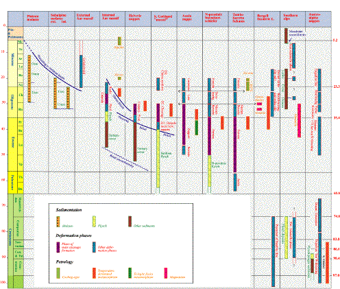
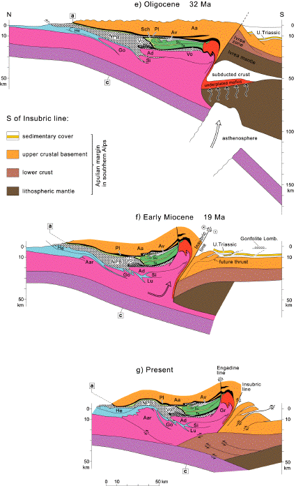
This discussion largely focuses on the evolution along the eastern (NFP-20 East) transect of Figure 3c where timing is best constrained. Figure 4 gives a timetable of orogeny, while Figure 5 depicts cross sections along this eastern transect for different time slices.
|
Fig. 4: Correlation table showing an attempt to date deformation phases and metamorphism along the eastern transect (NPF-20 East). For an extensive discussion of timing constraints see Schmid et al. (1997), for a brief overview, see Schmid et al. (1996). From Schmid et al. (1996). (Large image)
|
6a. Cretaceous orogeny
Cretaceous (or Eo-alpine) orogeny in the Eastern Alps is regarded as independent and unrelated to Tertiary orogeny because of its different kinematic scenario (top WNW, hence almost orogen-parallel thrusting) and because it is separated from Tertiary convergence by an extensional event during the Late Creatceous ("Ducan extension" in Figure 4). Apart from the Austroalpine nappes, it only affects the Piemont-Liguria units of Eastern Switzerland (Arosa-Platta) while the rest of the Penninic units remains largely unaffected by this orogeny which did not propagate further to the west beyond Eastern Switzerland, nor down-section into the Briançonnais units.
The attribution of a pre-Adamello phase in the Southern Alps (main deformation of Miocene age) to Cretaceous orogenic activity is uncertain, but a precursor of the Insubric line must have been active (separation between the detached crustal flakes of the Austroalpine nappe system from the Adriatic lithosphere which remained intact). However, the southern margin of the Piemont-Liguria margin represented an active margin, as documented by the accretionary wedge of the schistes lustrées and by the eclogitization of the Sesia unit at around the Cretaceous-Tertiary boundary.
During the various stages of Tertiary orogeny, the pre-structured Austroalpine nappe system, together with the Arosa-Platta ophiolites, formed a rigid upper plate (referred to as "orogenic lid" in Figure 5), of which the Southern Alps (not depicted in Figure 5a to 5c but present at the southern margin of these figures) formed part.
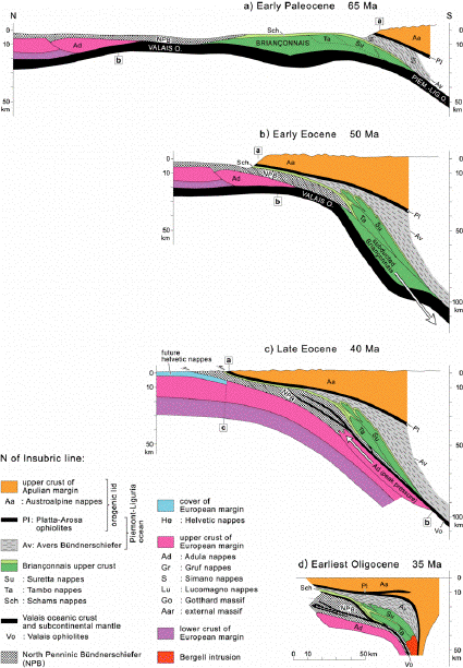
Fig. 5a-d (Large image)
6b. Early Tertiary convergence and subduction (65-50 Ma)
During the Paleocene the Briançonnais terrane enters the subduction zone, thereby closing the last remnants of the Piemont-Liguria ocean in eastern Switzerland, the youngest sedimentary cover of which now forms an accretinary wedge consisting of the Avers Bündnerschiefer (Figure 5a). Very probably, this southern ocean remained open for a longer period of time in the Western Alps. After some 200 km of N-S-convergence (1.3 cm per year) the distal margin of Europe (future Adula nappe) enters the subduction zone at around 50 Ma, now closing the Valais ocean (Figure 5b). Penetrative deformation during this time interval is largely restricted to the southernmost Penninic units, i.e. the Briançonnais terrane (Tambo-, Suretta- and Schams nappes, see Figure 4) and the Avers Bündnerschiefer of the Piemont-Liguria ocean (Figure 5b).
6c. Tertiary collision (50-35 Ma)
During the middle and late Eocene (i.e. between Figure 5b and 5d) some additional 200 km N-S plate convergence (corresponding to 1.5 cm per year) were taken up by the incorporation of the Valais ocean and the distal European margin into a growing accretionary wedge below the orogenic lid formed by the Austroalpine nappes. Figure 4 illustrates the migration of deformation and metamorphic events towards the northern foreland, reaching the area of the future Helvetic nappes by the end of the Eocene.
Note that a total of some 400 km N-S convergence across the Central Alps asks for substantial sinistral strike slip movement across the future Western Alps (see discussion in Schmid and Kissling, 2000). Hence, the western Alps formed under a sinistrally transpressive scenario during Early Tertiary convergence and collision, with W-directed movements post-dating Tertiary collision (see post-collisional stage 1).
Since the Alpine nappes in Figure 5 exclusively consist of thin slices of upper crustal basement and/or its cover, detached from their lower crustal and mantle substratum, all European (and Valaisan) lower crust (including parts of the upper crust) must have been subducted together with the mantle lithosphere (Figure 5c). Hence, N-vergent nappe stacking during this collisional stage took place within an accretionary wedge which starts to grow as more non-subductable upper crustal granitic material of the European margin enters the subduction zone. Radiogenic heat production within this granitic basement, perhaps in combination with slab break-off (depicted in Figure 5e) leads to a change in the thermal regime and to Barrovian-type (Lepontine) metamorphism.
|
Fig. 5e-g (Large image)
|
|
Fig. 5: Scaled and area balanced sketches of the kinematic evolution of the eastern Central Alps from early Tertiary convergence (a-b) to collision (c) and post-collisional shortening (d-g). From Schmid et al. (1996)
|
6d. Post-collisional stage 1 (35-20 Ma)
Further growth of the accretionary wedge leads to a situation whereby part of the material entering the subduction zone has to be retro-thrusted above the steeply N-dipping Insubric line towards the surface (Figure 5e and 5f). A "singularity point" (Beaumont et al., 1994) develops within the lower part of the upper crust, separating the subducting part of the European crust from that part of the wedge which is back-thrusted and -sheared in order to be exhumed by erosion (this singularity point is near the bent arrow depicted in Figure 5f).
As can be seen from Figure 4, forward thrusting in the Helvetic nappes (i.e. the Glarus thrust) is contemporaneous with retro- or backward thrusting along the Insubric line. Hence the orogen now becomes a bivergent one with a southern and northern foreland. Interestingly, this transition into bivergent thrusting coincides with increased rates of erosion due to the pop-up of the central Alps between fore- and retro-thrusts. This provokes the transition from flysch to molasse type sedimentation in the northern foreland.
N-S directed plate convergence during this first post-collisional episode amounting to about 60 km, slowed down to some estimated 0.45 cm per year. In map view, this time interval coincides with the WNW-directed movement of the Adriatic plate, now decoupled from the central Alps via dextral strike slip movement along the Tonale line (some 100 km). Kinematically, the western Alps are now part of the WNW-moving Adriatic plate and are separated from the Central Alps along the Simplon ductile shear zone and later on by the Rhone-Simplon line (see Figure 1).
Note that continental rifting in the Rhine and Bresse grabens falls into this same time interval. However, this rifting is kinematically unrelated to shortening across the Alpine system which remains in compression throughout.
6e. Post-collisional stage 2 (20-7? Ma)
Further crustal overthickening within the central part of the Alpine orogen by bivergent (retro- and pro-wedge) thrusting eventually led to a rather rapid propagation of the deformation front from the Insubric line towards the Po plain (Southern Alps), as well as towards the northern foreland (thrusting at the base of the Aar massif and within the southern Molasse basin) at around 20 Ma ago. This is depicted in Figure 5e while the timing constraints are given in Figure 4. Regarding the Southern Alps, deformation stopped at around 7 Ma ago (Messinian unconformity).
In the northern foreland, however, the situation is more complex. During the late Serravallian (12 Ma), deformation suddenly stepped further into the foreland, now also incorporating the western part of the Molasse basin and the Jura mountains into the orogenic wedge (Burkhard and Sommaruga, 1998). Whilst decollement along Triassic evaporites is recognized by most authors as being responsible for this forward stepping of the deformation front onto the northernmost Jura mountains up to the southern Rhine and the Bresse grabens two questions remain open:
(1) Did thin-skinned deformation stop at around 7 Ma in the Jura mountains, i.e. contemporaneously with foreland deformation in the Southern Alps?
(2) How exactly did the arc of the Jura mountains form: clockwise rotation of the western part of the Molasse basin and the northern Alps as proposed by Laubscher (1961), or W to NW-directed indentation of the western part of the Central Alps as proposed by Burkhard (1990a)
In regard to the first question we will argue below that present-day deformation is thick-skinned, hence it is likely that Jura-folding was a short-lived event (12-7 Ma). Regarding the second question we favor an indentation model since there is evidence for counterclockwise rather then clockwise rotation of the Adriatic plate during the Miocene (Schmid and Kissling 2000).
Assuming that relatively fast plate convergence across the Alpine system of Switzerland stopped at around 7 Ma, the 60 km plate convergence over the duration of this second post-collisional episode amounts to about 0.5 cm per year. Hence plate convergence remains practically unchanged between 35 and 7 Ma. It will be interesting to compare this figure of 0.5 cm per year to present-day shortening estimates across the Alpine system.
6f) Recent movements in the Upper Rhine graben area
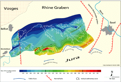
Figure 6 depicts some recent results from work in progress in the framework of EUCOR-UGENT (M. Giamboni, unpublished) concerning the area of the Upper Rhine graben in the Sundgau area west of Basel. The Sundgau Schotter have been deposited during a very short time interval from 3.2 to 2.6 Ma according to Petit et al. (1996). Presently they outcrop within a 20 km wide corridor between the Vosges and the frontal Jura mountains (see outlines of the base of the Sundgauschotter indicated in Figure 6). The base of these Sundgauschotter forms an excellent reference horizon for inferring relative vertical movements during the last 3 Ma or so (their basal part needs not to have been deposited 3.2 Ma ago everywhere, but certainly before 2.6 Ma ago) provided that this basal contact may be assumed to be near-horizontal at the time of deposition. The fact that these gravels were deposited in a braided river environment indicates that their basis may be assumed to be nearly planar, with some very minor slope from E to W which cannot substantially modify the picture emerging from Figure 6 which is the following:
The contour map of the base of the Sundgauschotter (Figure 6) suggests substantial relative vertical uplift of the southernmost part of the depositional corridor in respect to the northernmost occurrences (in the order of 250m). Moreover, two very pronounced en-echelon anticlines, gently folding the base of the Sundgauschotter are inferred north of the Vendlincourt fold in the Rechésy area, these gentle folds being directly observable within Upper Jurassic limestones and Oligocene deposits below the base Sundgauschotter. Note also that the base Sundgauschotter is affected by at least part of the folding to be observed in the Ferrette fold.
The geometry of these folds, particularly in the area immediately east of Montbéliard, suggests thick-skinned reactivation of basement faults formed during Oligocene rifting. Hence, we propose a thick-skinned origin for approximately NNW-SSE-directed ongoing shortening, as indicated by the northernmost (post 3 Ma) folds in the Basel area affecting the Sundgauschotter and very probably going on at present. This suggests that thin-skinned Jura folding may indeed have stopped some 7 Ma ago. Such a postulate is compatible with (1) the present-day stress field in the Jura mountains, as determined by in situ stress measurements (Becker 1999) which indicates that the Jura belt is no longer an active thin-skinned fold and thrust belt and (2) by the inference that the historical Basel earthquake reactivated a deep-seated basement fault (Meyer et al., 1994), and (3) the ocurrence of intra-crustal earthquakes within the Molasse basin (Figure 3c).
|
Fig. 6: Contour map of the base pf the Pliocene (3.2-2.6 Ma) Sundgau gravel deposits W of Basel. Assuming an originally planar base of these braided river deposits, the contours indicate folding with an amplitude of up to 200m. This indicates substencial tectonic movements during the last 3 Ma, post-dating thin-skinned Jura-tectonics. From Giamboni and Schmid, work in progress. (Large image)
|
References
Beaumont, C., Fullsack, P.H. and Hamilton, J., 1994. Styles of crustal deformation in compressional orogens caused by subduction of the underlying lithosphere. Tectonophysics, 232, 119-132.
Becker, A., 1999. In situ stress data from the Jura mountains — new results and interpretation. Terra Nova, 11, 9-15.
Burkhard, M. (1990a). Aspects of large-scale Miocene deformation in the most external part of the Swiss Alps (Subalpine Molasse to Jura fold belt). Eclogae geol. Helv., 83, 585-602.
Burkhard, M. (1990b). Ductile deformation mechanisms in micritic limestones naturally deformed at low temperatures (150-350°C). In: R.J. Knipe et al. (Editors), Deformation mechanisms rheology and tectonics, Geol. Soc. Spec. Publ., 54, 241-257.
Burkhard, M. and Sommaruga, A., 1998. Evolution of the western Swiss Molasse basin: structural relations with the Alps and the Jura belt. In: Mascle, A. et al. (eds), Cenozoic Foreland Basins of Western Europe. Geol. Soc. Special Publ., 134, 279-298.
van Daalen, M., Heilbronner, R. and Kunze, K. (1999). Orientation analysis of localized shear deformation in quartz fibres at the brittle-ductile transition. Tectonophysics, 303, 83-107.
Fitz Gerald, J.D. and Stünitz, H., 1993. Deformation of granitoids at low metamorphic grade. I: Reactions and grain size reduction. Tectonophysics, 221, 269-297.
Froitzheim, N., Schmid, S.M., and Frey, M., 1996. Mesozoic paleogeography and the timing of eclogite-facies metamorphism in the Alps: A working hypothesis. Eclogae geol. Helv., 89, 81-110.
Giamboni, M., work in progress. Please contact marzio.giamboni@unibas.ch for further information concerning the Sundgau Schotter or pierre.dezes@unibas.ch concerning the EUCOR-URGENT ("Upper Rhine Graben: Evolution and Neotectonics") project.
Handy, M.R. and Zingg, A., 1991. The tectonic and rheological evolution of an attenuated cross section of the continental crust: Ivrea crustal section, southern Alps, nortwestern Italy and southern Switzerland. Geol. Soc. America Bull., 103, 236-253.
Jordan, P., 1994. Evaporite als Abscherhorizonte: Eine gefügekundlich-strukturgeologische Untersuchung am Beispiel der Nordschweizer Trias. Beitr. Geol. Karte Schweiz, NF 164, 79pp.
Laubscher, H.P., 1961. Die Fernschubhypothese der Jurafaltung. Eclogae geol. Helv., 52, 221-282.
Meyer, B., Lacassin, R., Brulhet, J. and Mouroux, B., 1994. The Basel 1356 earthquake: which fault produced it? Terra Nova, 6, 54-63.
Maurer, H., Burkhard, M., Deichmann, N. and Green A., 1997. Active tectonism in the central Alps: Contrasting stress regimes north and south of the Rone valley. Terra Nova, 9, 91-94.
Okaya, N., Freeman, R., Kissling, E. and Mueller, S., 1996. A lithospheric cross section through the Swiss Alps, Part 1, Thermokinematic modeling of the Neoalpine orogeny. Geophys. J. Int., 125, 505-518.
Petit, Ch., Campy, M., Chaline, J. and Bonvalot, J., 1996. Major hydrographic changes in Alpine foreland during the Pliocene-Pleistocene. Boreas, 25, 131-143.
Schmid, S.M., Pfiffner, O.A., Froitzheim, N., Schönborn, G., and Kissling, E., 1996. Geophysical-geological transect and tectonic evolution of the Swiss-Italian Alps. Tectonics, 15, 1036-1064.
Schmid, S.M., Pfiffner, O.A. and Schreurs, G., 1997. Rifting and collision in the Penninic zone of eastern Switzerland. In: Pfiffner O.A. et al. (eds.), Deep Structure of the Alps, Results from NFP 20, 160-185.
Schmid, S.M. and Kissling, E., 2000. The arc of the western Alps in the light of geophysical data on deep crustal structure. Tectonics, 19, 62-85.
Schönborn, G., 1992. Alpine tectonics and kinematic models of the central Southern Alps. Memorie di Scienze Geologiche, XLIV, 229-293.
Sue, Ch., Thouvenot, F. and Fréchet, J., 1999. Widespread extension in the core of the Western Alps revealed by earthquake analysis. J. Geophys. Res., 104, B11, 25611-25622.
Tullis, J., 1983. Deformation of feldspars. In: P.H. Ribbe (Editor), Feldpar Mineralogy (Reviews in Mineralogy, Vol. 2). Mineral. Soc. Am, 2nd Ed. Washington DC, 297-332.